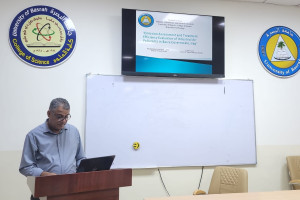
The college of science at the University of Basrah organized a seminar on "tectonomorphometric analysis of the zerbatya region of eastern Iraq using remote sensing and" GIS
The seminar aimed to shed light on Tectonic and geomorphological influences in the zerbatya region, the study of linear structures and geological features using remote sensing and GIS technologies. The seminar, which was attended by the student (Ghadeer Khaled Jalal), included the assessment of the tectonic activity of the region through the use of morphotectonic indicators and the analysis of the density of lineaments and their relationship to tectonic movements, which contributes to the understanding of sedimentary environments and geological structures affecting the region.
Important News
viewed most