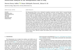
The Department of Geology at the College of Science organized a panel discussion entitled (Spatial and temporal forecasting based on geographic information systems for cutting points - water for the AB region in the Zubair Formation and the South Rumaila oil field, using geological statistics and artificial intelligence techniques). The workshop, which was lectured by the researcher Israa Qasim Saleh, aims to create machine learning models that can predict the spatiotemporal location of the water cut-off interface in the AB reservoir unit.

The study included an examination of the petrophysical properties of the AB reservoir unit using a number of sensors, namely, a gamma-ray sensor, a resistivity sensor, a density sensor, and a neutron sensor, as well as an interpolation of these properties using the ArcMap program, using interpolation methods, namely (IDW), Kriging Ordinary and Empirical Bayesian Kriging.
The results concluded that the oil production increases as we move towards the west of the study area due to the increase in permeability, and the type of reservoir rock is sandy sandstone, and the production decreases as we move towards the middle of the study area. Water saturation is low in the southern half of the study area, which indicates that oil is high.